Other than one day of surface survey in the Shiawassee National Wildlife Refuge, field time in October through mid-November was spent at the Steltzriede Farm site (20SA562) in Saginaw County. Oral tradition, passed on by the late Ralph Stroebel, indicates that a log cabin was built at the site in 1838, followed by a frame house in 1848. The 1848 structure, with subsequent additions, still stands. Stroebel, a noted local avocational historian (and charter member of the Michigan Archaeological Society) had strong personal ties to the property. The Steltzriedes, who founded the farm, were his maternal grandparents and he spent much time there in his youth. Further, Stroebel reportedly dug into and found traces of the 1838 cabin including chinking with split log impressions and remnants of a wall or foundation. Interestingly, neither the 1877, 1896, nor the 1916 plat maps show a house in this location. The farm has since been subdivided.

Nick and Ken excavating at Steltzriede Farm site.
We focused our efforts on two areas of the present property, one being the reported location of the 1838 cabin. Unfortunately, despite digging a 1X9 meter trench across the area where the cabin was thought to have been located, we were unable to find any direct evidence of the structure. We did, however, find several square nails, thin window glass fragments, brick fragments, saw-cut bone, and a few ceramic sherds, all of which are consistent with an early to mid-19th century dwelling.
During drought conditions several years ago, the current landowner noticed a rectangular pattern of dead lawn in the yard on the west side of the 1848 house. This was our second area of focus. Using probe rods, we were able to locate a solid structure and trace three sides of what appeared to be a foundation. We excavated a shovel test over the structure, which we later expanded into a 1X1 meter excavation unit, and revealed a cobble and mortar construction. A harrow spike was found lying directly on top of the foundation.

Harrow spike resting on top of cobble and mortar foundation.
A harrow is a farming implement used to break up clods and smooth the soil after plowing. The harrow could be pulled by animals or a tractor. Here is a close-up of the harrow spike. Like most of the iron objects from the site it is heavily corroded.

Harrow Spike
We excavated two square meters along the inside of the foundation. The top of the foundation is capped by approximately 20-30 cm of fill. The fill is likely derived from excavating the basement of one of the additions to the 1848 house. Artifacts found in and below the fill include nails, brick fragments, mortar, corroded iron scraps, and a few pieces of glass and ceramics. The base of the foundation is approximately 70 cm below the present land surface. At the time of construction it would have been closer to 40 cm below the surface.
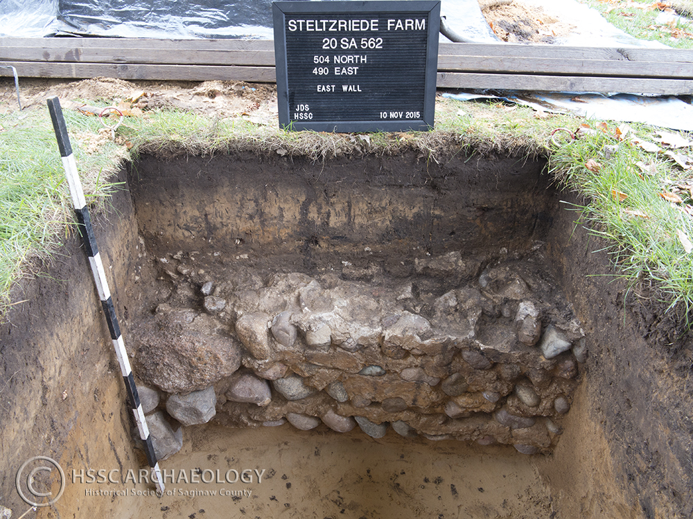
Profile of cobble and mortar foundation.
The final excavation unit in this location was placed on the “open” side of the structure where we were unable to trace the foundation with the probe rods. Here we found a deeper layer of sand, clay, and gravel fill, extending 50+ cm below the present surface. This material contained an abundance of brick and mortar fragments, nails, glass, bone, a whetstone, and a “mystery object” consisting of a 4 cm diameter lead disk with iron loops set perpendicular to each other on each face. Any suggestions for a possible ID? Please share in the comments below!

Whetstone

Mystery Object
True to form, on what was supposed to be the final day of fieldwork, we encountered a feature in the excavation unit. Starting in the 55-60 cm level, we began to see the corner of a rectangular pit dug into the subsoil. The feature contained material very similar to the fill from the upper portions of the unit. The bottom of the feature was reached at a depth of 83 cm below the present surface. Near the bottom of the feature we recovered a portion of a clear glass bottle. The bottle exhibits a “tooled finish” and what appears to be an air vent mark just below the neck. According to information provided in the “Historic Glass Bottle Identification and Information Website” developed by the Bureau of Land Management and hosted by the Society for Historical Archaeology, this bottle probably post-dates the 1880s. [This website is a great resource for anyone interested in identifying bottles.]

Feature 1 Plan View at 75 cm.

Flask from Feature 1.
It is not clear what relationship, if any, this feature has to the structure represented by the cobble and mortar foundation. In fact, at this point not much at all is clear about the structure. Like so often happens, our preliminary work at the Steltzriede farm site raised more questions than we answered. We do not know what the structure was, or when it was built. A circa 1890s photo of the area shows no indication of the structure, nor do any more recent photos that we have seen. This, along with the fact that Ralph Stroebel was apparently unaware of a former structure at this location, may indicate that it is early in the occupation sequence. Having only traced three sides of the foundation, we don’t know the actual size of the building. It may have been a three-sided barn or shed-like structure, or perhaps the south wall was dismantled – the current position of the driveway makes this a distinct possibility. In any case, we’ll have the winter to ponder these questions. We’ll almost certainly return to the site next year to see if we can come up with some answers.

Another fascinating dig! I grew up in the neighborhood directly behind the Steltzriede Farm (Also known as Centennial Farm) My parents house is on the corner of Henry (for Henry Steltzriede) and Sunny Lane. Later in life I bought the house on the corner of Henry and Burbank. I can see the farm from my driveway. A few years ago I found in my back garden (not sure where exactly anymore) a length of corroded metal that looks very old and perhaps a part of a farming implement. Its about 8 inches long, give or take. My yard is directly across the street from the last portion of the Steltzreide farm that was active. It was sold to The Lutheran church that stands there now in the early 60’s I think. I’ve always wondered if this piece of metal might have come from the days of Henry and Katherine when they farmed in what is now my yard. An old well is located near the play equipment of the church. It is now a small garden area, but I remember the old water pump being there for many years when I was growing up. I can bring the piece of metal to the museum if you are interested in looking at it. Let me know. John Fry
John, thank you for the comment. I have heard, though I haven’t checked it out, that the church play area also contains a circular sandbox that is the base of a silo from the Steltzriede Farm. It’s pretty neat that, despite the myriad of changes, traces of the former agrarian landscape remain as visible reminders of the past. If you would like to bring in the piece of metal you found, I will be happy to take a look at it. Perhaps we can figure out what it was from.
Interesting dig and finds.
Greetings from an archaeology student in Sweden.
Sure, It would be interesting to find out what it might be. I wish I had known the dig was going on at the old Steltzriede house I would have walked over and watched them dig. Hope you return next summer. JF